Blodgett Peak Trail
NOTE: Due to the recent fires, this trail has been closed until further notice
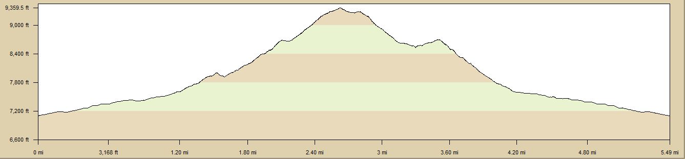
| TrailHead Coordinates N38.949019 W104.886153 | Start Elevation 7085 ft | Highest Elevation 9380 ft | Lowest Elevation 7085 ft | Elevation Gain/Chg 2295/4590 ft | Current Weather - Click for details |
Trailhead / Access
There are several ways to access Blodgett Peak, this one show the most popular route. The trail starts at the Blodgett Open Space parking lot. The lot is off Woodmen Road and can be reached from I25 by exiting at Woodmen Road. Follow Woodmen Road up into the Perigrine Developement til you see the parking area. Parking is limited but you can also park on Woodmen on either side of the lot entrance. You can also reach the lot from the south by taking Garden of Gods Road to Centenial and follow Centential which wiil turn into Woodmen Road.
Trail Description
The trail starts out on the access road to the water tank which is .9 miles from the parking lot. Travel past the tank and there is a narrow trail on the far side that heads north and west. Follow this trail and it ends at a wider trail/dirt road. Turn right and go about 50 yards. The trail you want takes off to the left into the trees. From this point until the top, the trail will climb and get steeper as you proceed. Stay on the trail that keeps you on the left of the creek bed.
After you get to about 1.7 miles, the trail gets a bit harder to follow. This is where most of the markers lead you across the creek bed and up the hill. This section is very steep, with a lot of loose scree. In looking at the GPS tracks, it is obvious that outbound and inbound followed a bit different courses. Because of the steepness and loose soils, it does not take to showing a track.
Once you are up and past the rock slide, the trail comes together again and continues to climb til you reach the top, here you turn right and follow the cairns around the final peak area and come up from the back side. I did not do this last piece because if was not easy for my dog to handle the rocks. I have been there before so I know it is just a short stretch at this point.
Coming down, I tried to find a different route that was not so steep but ran into a cliff so had to back track and bushwack back to the original trail. From the plot, you can see a slightly different path for the steep section. No trail, pick a descent that you can handle, it all reachs the same point eventually.