Cheyenne Mountain State Park
| TrailHead Coordinates N38.949019 W104.886153 | Start Elevation 7085 ft | Highest Elevation 9380 ft | Lowest Elevation 7085 ft | Elevation Gain/Chg 2295/4590 ft | Current Weather - Click for details |
Trailhead / Access
Cheyenne Mountain State park can be reached by taking I-25 to exit 135 (South Academy) and heading west. When you reach Hwy 115, turn left and go to the first stoplight. Turn right and follow the road to the park entrance.
Trail Description
Cheyenne Mountain State Park is another of the great parks found in Colorado Springs however, this one is a state park. This
park is one of the newest parks in the area and can be found in the vicinity of Cheyenne Mountain. It first opened to the public i
in October of 2006 although some of the camping facilities are not yet open but expected to be very soon. Since this is a state park,
a park entrance fee is required of all vehicles entering the park. The facilities at the parking lot are excellent
with clean restrooms and picnic areas and the trail well designed. Hopefully these can be kept in top condition as time goes on.
The park has about 20 miles of trail spread over the area in a series of trails of different difficulty and distances. There
appears to be a trail for every category of user. For the purposes of this webpage, I have not mapped specific trails but
groups of trails to highlight different distances and sections of the park. The signs in the park and on the trails is great. At
every trail intersection, there is a major sign showing the entire trail system and showing your position
at that point so you can verify with your GPS unit or trace to a map. I makes it very easy to follow the trails particularly since there are about 16
trails that wander around and cross each other. There are also small circular signs that give
GPS data and indicate what trail you are one. There are no mileage markers, I think because there are so many variations of the trails
that it would be hard to decide what route someone was following. I have included for this location, a link to the pdf trail map
provided by the park because it has an excellent overview of the trail system and facilities. No sense in reinventing the wheel.
Hopefully, my trail maps will supplement their map with a sense of dimension, that is how the trails fit with the terrain of the park.
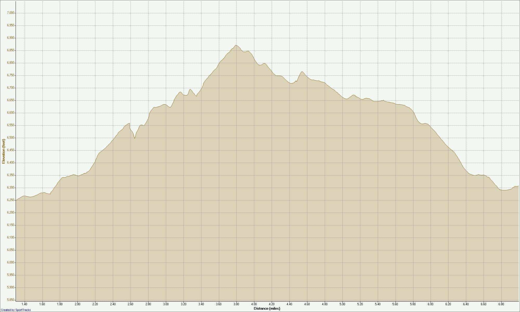
Course 1 - 8.4 miles
This course takes you over the southern to south eastern sections of the park. It starts on the sundance trail. This trail section was rolling meadows. The talon trail could also work to get you to the southern trails. We chose to go out on sundance and return of talon. Sundance and talon cross and the talon trail is the one to take at this point. This will lead you to the far southeastern section and 2 loops, north talon and south talon. These loops are more rugged and footing is more rocky than the trail leading into them.
After completing the two loops, you can go back out on the talon trail to the trail head or take the rest of the sundance trail back to the trail head. In all, this was about and 8.25 mile course, good for a middle distance run with a good amount of short ups and downs to work the hill muscles.
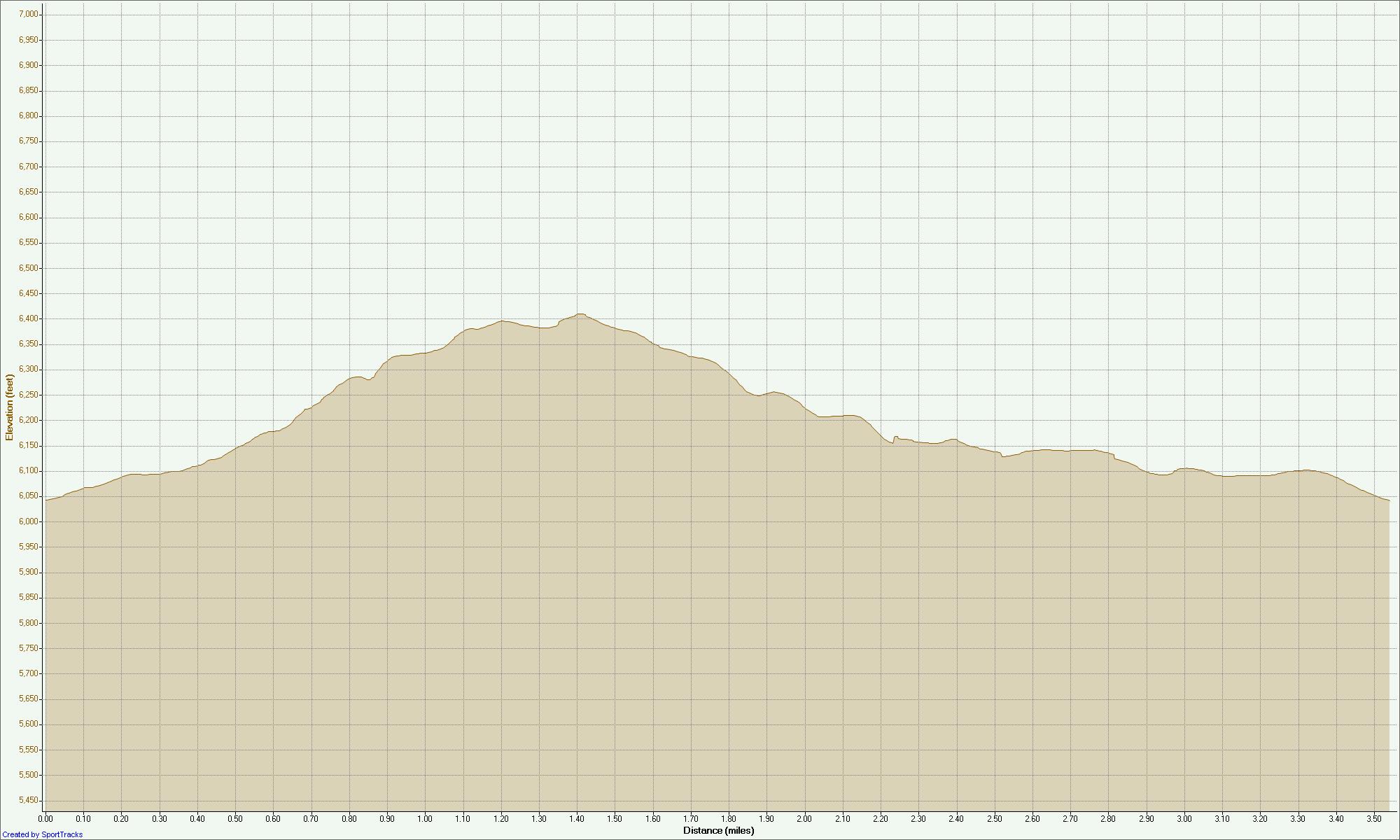
Course 2 - 3.5 miles
This course was done the same day as Course 1 to add another 3-4 miles to the workout. By itself, it would make a good short distance run but might need a little more to make it 5 miles (the distance I like during the week). For this one, you can start on either sundance or talon but shortly, you will branch off on the zook loop. Going to the left or right will take you to the blackmer loop. This loop is 3.5 miles but for this course, we only stay on it for a mile or so. At this point, you will take a right on the boulder run (which has as the name implies, a lot of boulders on the trail) and follow this to the coyote run. There is a section of this where the trail can be confusing.
The coyote run to the left goes through a picnic area and it is not real clear where the trail goes. If you get confused, going right or left through this area will place you at an intersection of roads near the main picnic area. Look across the roads for the coyote run trail to take of to the west. This is where you want to be. I went west to add miles to the run and looped the coyote trail until I came back to the zook trail where going left a short distance takes you to the sundance trail and left to the trail head.