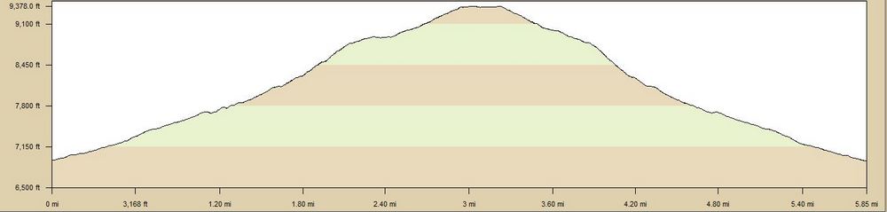
| TrailHead Coordinates N38.938138 W104.881704 | Start Elevation 6930 ft | Highest Elevation 9370 ft | Lowest Elevation 6930 ft | Elevation Gain/Chg 2450/4900 ft | Current Weather |
Trailhead / Access
The best place to pick up this trail is to take Allegheny Blvd west from Centennial to Front Royal Drive. Turn left here and the next street is Coldwater Drive. Turn left here. There is limited parking along the street here near the end of the street. A opening in the fence provides access to the trail. There is also parking on Allegheny Blvd, where the the trail could be accessed easily in the past. Now there is a rock spillway that you would have to cross to get to the trail. This is mostly not a problem unless there is water present.
Trail Summary
Starting at the fence on Coldwater Drive, the trail takes off to the south west. After a short bit, it will turn mostly west and start climbing. The trail is surprisingly well defined and usable for an informal trail. It appears to be mostly decomposed granite so it should not suffer from mud. This section is a mixture of open meadows and clusters of scrub oak with a pleasant mixture of wild flowers in the early summer time. The trail is mostly about 2-3 feet wide and has plenty of clearance in the first mile. I would say that a skilled mountain biker would find this a good moderate level ride. In the first mile, there will be a few steeper sections of 50 yards or so where the climb gets harder. There are a number of trails branching off of the main trail so if you get easily confused, scratch a mark in the dirt to aid on the return trip.
After about a mile, the trail will enter into a more treed area. From this point on, pine trees will dominate the terrain. You will lose some of the vistas that you had but it might be nice in summer as you will gain the shade. Around this point, you will encounter a barbwire fence on the right of the trail. I always make a point of remembering this since if I don't see if on the way down, I have probably taken a different (or wrong) trail. There is a point just past 1 mile where the trail from the Blodgett Space joins this trail. The Blodgett Space trail goes right and it is easy to miss this when coming back down since it is wider looks to be the "trail" we are following. If you end up on this trail, you will be about a mile away from where you parked your car when it lets out on Centennial/Woodmen Rd. Also, The trail coming up from Blodgett is named as part of the Foothills Trail on some of the planning maps but it is never real clear about it and whether the unnamed trail we came up is part of that or not.
From this point on, the trail will be progressively steeper. The steepness continues until just before 2 miles where it will open up into a fairly flat meadow. In the winter, it is hard to find your way to this point as the trail is not very distinct. In the summer, you can pick out the trail and there are a series of rock carins that have been layout to help find the way. The trail parallels the creek and more recently because it is getting more use, the trail has become more distinct. It is about where the trail starts to move away from the creek bed, that is becomes less distinct but it is not too hard to follow if you pay attention.
From the clearing, the route to the summit becomes difficult to follow. The trail is quite faint and at times seems to almost disappear. There was no "trail" where I left the meadow but someone had places a bit of plastic bag on a tree. I started working my way up towards the top from there and was able to just barely make out a trail. Between some pieces of plastic bag and some rock cairns, I did manage to follow the trail. It is about 3/4 mile from the meadow to the top of the ridge. The trail bends south where in the past I had tried to go north to get to the top.
The descent was almost as difficult as the ascent. The steep climbs become very slick descents and you need to pick you
footing carefully. The scree on the trail is very slippery, but Since I have talked to people who have been to the summit on this trail, I know there must be a better route and will continue to search
for it.