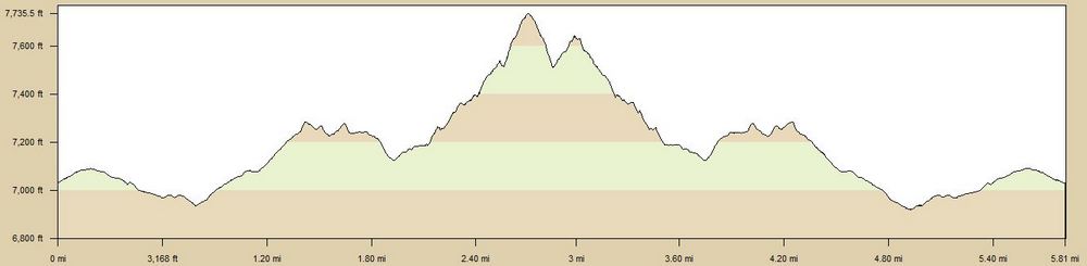
| TrailHead Coordinates N38.980899 W104.886138 | Start Elevation 7050 ft | Highest Elevation 7735 ft | Lowest Elevation 6935 ft | Elevation Gain/Chg 705/1450 ft | Current Weather |
Trailhead / Access
Access to the trail requires some hiking to get to the start of the creek. CSU has blocked off the area around the valley and access is allowed only on Trail 713. Trail 713 can be picked up from the Falcon Trail. The nearest parking area to access the Falcon Trail is a small dirt turnout/parking area off of Pine Drive. There is room for about 7-10 cars. There is no formal parking places.
Trail Description
The trail proceeds west from the parking area on a wide dirt trail. At about 1/2 mile, you will run into the Falcon Trail. Turn left and go about 1/3 mile where there is clear signage indicating the Trail 713 route, where you will turn right and head west again.
This section winds thru open meadows gradually gaining altitude until you reach the top of a ridge where you can see the Telsa hydroelelectric plant just ahead. The trail will take you to the roadway for the plant, so follow it to the left and down about 1/4 mile to a dirt road heading west again. It will just be a short distance when you will encounter a fence barring you from continuing straight. Here Trail 713 turns right and start climbing up the ridge. This is the steep and rocky part of the trail. A word of caution. You reach a point where it looks like the trail turns left but this is false. This will just take you a short distance and the trail will disappear and leave you on a sloped section which because of the crushed granite base could be slippery and it is has a significant dropoff. I think the trail originally followed this route but between building the pipeline through this area and washout, it is no longer the trail nor is it safe.
If you turn right instead, the trail narrows to a single track which is steep and rocky with the scrub oak intruding on the trail. This again reaches a point where the trail has suffered. This is another area where caution is advised. I turned back here but just past this area, the trail start dropping down into the valley and you will now be following the original Monument Creek Trail. The trail again is blocked a couple miles ahead by CSU facilities and Trail 713 turns right and head up the ridge. This is as far as I have travelled to date but will be adding to this as time permits.
I did a different approach to this trail by following the Blodgett-AFA course to the Falcon Trail then picking up Trail 713 as above. Distances were similar. The main advantage was not having to drive to the AFA to start.